My Response:
I believe that this El Nino will turn out to be a west/ central based nina due to the modelling showing the warmth migrating westwards into nino 3.4 and cooling nino 1 and 2. This usually gives much colder conditions to North America in winter and fall as opposed to an east based Nina. These are my analogs for this october. I give 1 spot on the list for each of he following 1) Warm AMO 2) Cold PDO decadaly (overall) 3) PDO flipping to warm during the fall/winter. All my years are el nino's coming off of 1 or more la nina's.
The core of the cold is across the Northern Plains but florida stays about normal to slightly below normal. I don't see any heat waves for october or even any of the fall for florida although it may certainly be above normal at times.Taking a look at the SST's off the Florida coast and up the majority of the eastern seaboard we see colder anomalies which would signal more cooling and troughiness in the southeast.
The JMA model has florida cold for the fall as well in terms of temps. CPC analogs show this from there super ensembles:
These years look cool in the southeast for october with warmth across the north but should be taken lightly because this models analogs change daily:
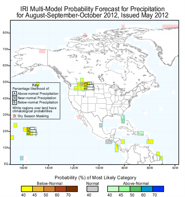
The IRI has a lot of wetness in florida for the late summer/ early fall meaning that it will be generally cooler. This is probably signally possible tropical threats.
On the topic of precipitation I believe that there will be a lot of in close development with hurricanes and many tropical moisture threats for florida resulting in a wetter then normal summer and a cooler fall with very little chance of a big heatwave. I hope I answered your question, thanks for commenting!


No comments:
Post a Comment