
ONI ERSSTv4 Data courtesy of the Climate Prediction Center
Over the next 10 days, low level easterly winds are forecast to intensify near levels observed during the Late July event. The late July event had 850mb zonal wind anomalies near -7m/s.

Image courtesy of Michael J. Ventrice
As a response to the late July event, SST's took a clear dive along the equatorial pacific. Further dips occurred in August due to subsequent EWB's along the equator.

Image courtesy of Tropical Tidbits
The GFS forecast has slightly weaker anomalies{relative to the July event} but a larger radial coverage along the equatorial pacific basin. This could lead to another strong decrease in ENSO anomalies. We may approach SST levels that haven't been observed in several years.

Image courtesy of Michael J. Ventrice
The Latest weekly ENSO dataset {valid Aug 16} is listed below. A weekly Nino 1+2 anomaly has not been this low since February 2015.
Nino 1+2: -0.7C
Nino 3: -0.5C
Nino 3.4: -0.5C
Nino 4: 0.1C
From an atmospheric point of view, the La Nina response is beginning. GLAAM initialization is already less than -1sigma and is forecast to dip below -2sigma in the 10-14 day period. SOI values have been positive every day in August with the exception of 4. The 90 day mean continues to climb to the highest value recorded in months. With a July monthly mean of 6.51, August will likely come in higher with the upcoming EWB. It could surpass 13.90, which is the highest monthly value recorded since December 2011. This is unlikely at this point given the time remaining in August.

At this point in time, most of the climate models have a La Nada event. The CFSv2 has a weak to moderate La Nina. It is an east/central based event which is more favourable for a cold winter{midwest/east} when contrasted with a modoki event.

In my opinion, most of the other climate models{e.g ECMWF, JAMSTEC} are playing catch up with regards to the current observations going on across the pacific basin. The August update from the ECMWF monthly had a majority of members with a (+) Nino 3.4 anomaly during winter. It forecasted an august mean near 0 which is going to end up significantly too high. The UKM/JMA trended colder with their latest updates, depicting continued easterly trades in the SON period. If trade winds dominate, a La Nina is likely given the subsurface anomalies in place.
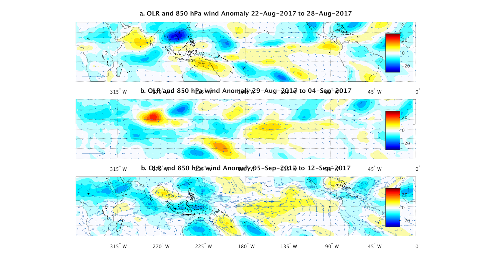
Trade winds are forecast to remain moderate through the first two weeks of September. Valid 8/22--8/28, 8/29--9/4 and 9/5--9/12.
The subsurface cold pool is evident and will continue to upwell slowly as easterly trades continue.

This could be one of the rare times where the CFSv2 scores a coup. Because its SST forecast updates on a weekly basis, it is more likely to respond to changes going on in the pacific. It has been consistent with its SST forecast and has support from observations. Monthly climate models could be steering in the wrong direction and it is making me question the extent to which the ECM/JAMSTEC forecasts{Aug updates} are useful going forward.