AO and NAO forecasts:
Another index I like to look at is the PNA which foretells what will occur downstream int eh eastern conus. When the PNA is positive it pumps the ridge across the western u.s and a trough digs into the west when the PNA is negative. A theory I have been looking into to help forecast the PNA is weekly sunspots which rotate from the maximum to the minimum every 13 days. I have found A negative correlation between the two indices. When the PNA is moving towards the minimum the PNA trends more positive and vice versa. The PNA is forecast to trend more positive in the next 10 days which supports the cold outbreak to end off the month of november. This will occur just after the sunspot cycle reaches its max which is currently happening which supports my theory.
Sunspot Activity:
Now on to the major storminess to end off the month. Our first storm will move up along the east coast between the 17th and 19th of november. Most models are keeping this storm offshore with minimal impacts along the east coast but i believe the models will correct west as we get closer to the event. Wind and rain will be felt along the east coast and interior snows possible across atlantic canada and maine. Our second storm will come in the form of an arctic cold front ushering in very cold air to the eastern half of the conus. This correlates well with the tanking of the ao/nao. 12z GFS at hour 364 illustrates this situation evolving.
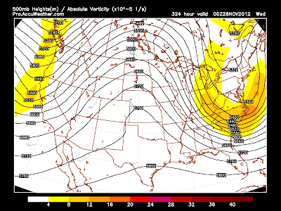
As the cold air is in place across the east and the NAO well negative we can expect a major storm or two for the end of november and beginning of december. The GFS is already beginning to sniff this out and is showing a major storm along the east coast. If this storm does occur which i believe will, it will move very slowly with strong blocking across the atlantic. Right now it is too far in advance to forecast exact location and impacts but a swath of snow on the northwest side and a major storm is likely in my opinion along the east coast or eastern great lakes.
500mb chart for this storm:
Surface maps shows the major storm with a cold outbreak to follow. This will set the stage for a cold and stormy start to december with a very negative NAO pattern and frequent cut-offs moving under the block to the north. Everyone have a great evening!


No comments:
Post a Comment