Monday, 28 May 2012

Severe Weather Update

0z NAM at 24 hours:

Wind Shear:

 Reduced 35%
Attached Image
972 x 696 (216.99K)


Storm Relative Helicity at 21 hours: very high in eastern ontario and high as well in southern ontario. Wind shear also seems much stronger towards eastern ontario, which leads me to believe that there will be an enhanced tornado threat in this outbreak as well as the last one unfortunately. I think Southern Ontario will have much less of a risk.

 Reduced 35%
Attached Image
972 x 696 (136.21K)


LI index at 21 hours looks really juicy in Southern Ontario for much of the day tuesday and then peaks for eastern ontario later in the day. Values lower then -10 are showing up over a large area.
 Reduced 35%
Attached Image
972 x 696 (193.86K)


Dewpoints Tueday at 21 hours get well above 70 F over a large area which is where we would like to be in order to develop strong and severe storms.
 Reduced 35%
Attached Image
972 x 696 (208.41K)


CIN showing less resistance to the CAPES, especially when daytime heating gets going and as the front passes through we will see low level convergence. We also have a lot of low level moisture which will help break the cap as well.

 Reduced 35%
Attached Image
972 x 696 (147.8K)


Nice tongue of very high theta-e in our areas signalling that the low levels of the atmosphere are very unstable and will try to produce storms through convection. THe cap should not have a problem breaking especially as the front moves in. With the front moving into the hottest and most humid air mass of the year I have trouble thinking that this will not get extremely severe if not the most severe outbreak so far this year for a large area.Until later tonight looks like we can enjoy the beautiful sunny weather as the atmosphere stays fairly stable, but watch out tonight into tomorrow! As you can see all the parameters are their before the action moves through (from 20 to 27 hours) to get something to really fire up. The bulk of the activity won't pass through till later then 24 hours.
 Reduced 35%
Attached Image
972 x 696 (207.3K)


This post has been edited by blizzardOf96: Today, 08:42 AM

Saturday, 26 May 2012

Severe Weather Outbreak Tuesday

Severe weather will begin to develop along a cold front as a trough digs in from the northwest, with a strong southwesterly flow in front out of it. This will cool the mid and upper levels of the atmosphere and allow air parcels to rise and develop strong cumulonimbus clouds.The trough will allow for high heat and humidity to build up in front of it fuelling the storms even more. Very high wind shear along with high instability will develop in the atmosphere. This will bring much above normal temperatures for Southern Ontario on Monday (30 feeling like 37 in the GTA), and on tuesday the heat core will move into Eastern Ontario. The bulk of the severe weather will move through Eastern Ontario about 12 hours later, along with the heat. The ECMWF and GFS agree on this feature except for the fact that the GFS is faster with the trough and has a smaller outbreak of severe weather. This is because it allows less heat and humidity to build and has lower CAPE and less shear. Nonetheless, it is still onto the same idea that a major outbreak will be headed our way. NAM has the same idea, pretty much except the timing needs to be perfected.


 Reduced 35%
Attached Image
SPC has a slight risk out for this monday throughout the great lakes region. Looks like the biggest threat extends from northern Illinois through Southern and Southwestern Ontario.

Attached Image
Probabilities at 15% for most of southern Ontario if you were to extend it:
 Reduced: 79% of original size [ 641 x 437 ] - Click to view full image
Attached Image

CAPE values are pretty high which supports the idea of severe storms firing up:

 Reduced 35%
Attached Image
972 x 696 (140.47K)

LI very supportive of strong and severe storms developing:
 Reduced 35%
Attached Image
972 x 696 (172.86K)


CIN are in the negative values showing a strong possibility of the CAP breaking, allowing air parcels to rise as they stay warmer than the surrounding air as height increases. This means the upper levels are undergoing a lot of cooling as the cap breaks and the surface warms. This combined with low level moisture from high dew points (13-18C) would support thunderstorms developing:
 Reduced 35%
Attached Image

In addition wind shear will be very high:
 Reduced 35%
Attached Image
972 x 696 (197.54K)


NAM EHI values(combo of CAPE and SRH) are close to or above one across a large area. Even though they are not extremely high, for them to be there this far out is pretty interesting. It is showing notable EHI values developing in a linear fashion which could be a signal of a tornado outbreak. The progression of this should be watched very closely as this could be a sign of just a few isolated tornadoes, none at all or the potential for a widespread outbreak. The shear is definitely there, and the EURO is showing that especially ( and it has been doing well lately). We will see.

 Reduced 35%
Attached Image

Friday, 25 May 2012

Severe Weather Firing Up In Eastern Ontario

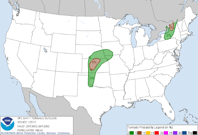
Warm and humid conditions are present in the eastern part of the country in advance of a cold front that is currently moving through southern ontario. A weak line of isolated thunder showers has set up along it, but it will intensity as it moves into Eastern Ontario and southern Quebec. A squall line with strong thunderstorms will develop along with strong winds, frequent lighting, hail and even maybe an isolated tornado. Here are the risk areas the SPC has put out (this would include an area that contains Montreal and Ottawa):
There is even a 5% risk for tornadoes, keep your eyes out in the Montreal area:

The 13Z HRRR is really showing the rapid intensification of this line of storms. This is due to the high dew points (in the 60's) and relative humidity, along with the front which gets the air to move upwards in one direction causing convection and the development of strong storms:


High CAPE values will help contribute to the rapid intensification of thunderstorms along this line. This will be partly caused by the surge of heat out in front and the sun coming out. Also VIL values are high enough to support hail in some of these cells:


The higher Storm Relative Energy Helicity Values gives the potential for some isolated tornadoes to form. This is a measure of shear in the atmosphere capable of making some cells rotate. Values between 150 and 300 usually indicate the potential for weak to moderate tornadoes:

Thursday, 24 May 2012

Getting Started

Just getting blog started, I hope to share my thoughts on upcoming short and long term weather events across Canada and the U.S.