Monday, 9 September 2013

El Nino Looking More Likely... Implications On Winter Pattern

Starting to notice subsurface anomalies really warming up now with yet another push of warmer then normal anomalies towards nino regions 1,2 and 3 below the surface. 

Surge of warmth was caused by a Kelvin wave that passed through the west pacific in the first few days of september allowing SOI values to drop significantly.
 Reduced: 94% of original size [ 539 x 259 ] - Click to view full image
Attached Image

Euro and NMME suite staying in the el nino or at least warm biased neutral camp and have been pretty consistent for several runs now. With this type of SST profile, positioning will be critical as a basin wide or east based warm event does not produce the goods in the east.

Euro SST profile not ideal with core of warmth near 120W.
 Reduced 27%
Attached Image
875 x 598 (88.34K)

In coldest el nino years we notice the core of warmth west of 130w. For example, 1963 in december was very cold in the east and had that type of setup.
 Reduced: 90% of original size [ 565 x 437 ] - Click to view full image
Attached Image

In 2002 and 1957 we have a basin wide nino in december and a very warm month across much of NA with the exception of the SE in 2002.
 Reduced: 90% of original size [ 565 x 437 ] - Click to view full image
Attached Image

Positioning of warm sea surface temperatures will be key... but could bear fruit if we see a favourable setup.

Saturday, 1 June 2013

May Verification and June Forecast

May Temperature Forecast Verification:

Here was my may forecast:
 Reduced: 79% of original size [ 641 x 417 ] - Click to view full image
Attached Image

Actual temperature departures for may:
 Reduced: 80% of original size [ 640 x 480 ] - Click to view full image
Attached Image

For my June temperature forecast I am going with a cold eastern/central part of the u.s. Their are several reasons why I am so aggressive on the cold when CPC has equal chances for june. 
 Reduced 35%
Attached Image
973 x 679 (486.3K)


1. Over the past few weeks we have been seeing wetter than normal conditions over the american midwest and western great lakes region. This means that when warm shots come racing out of the plains they will pack less of a punch then if the ground was already dry.

2. The MJO is headed into phase 2-4 over the next two weeks which favours a trough over the central and eastern part of the u.s. This will make it very difficult for temps to recover later on.
 Reduced: 93% of original size [ 547 x 547 ] - Click to view full image
Attached Image

3. Euro weeklies are strongly supporting a colder than normal june with the first 25 days of the month looking much cooler then normal in the midwest, great lakes and east with wet conditions along the gulf coast.

4. ENSO anomalies have turned much cooler in eastern ENSO regions relative to western ENSO regions. This will keep the core of the heat confined to the SW U.S and western rockies. I think B.C stays transient as systems move through and heights fall later in the month. Temps may end up slightly above normal.
Attached Image

It does look like we will see some very warm days in june across Ontario/quebec it just means that we will see more cloud cover and precipitation holding back departures in southern ontario. In eastern canada, northern ontario and the prairies temps look to average near to above average. This month should also feature above normal severe weather in the great lakes region with more clashes between warm and cool air masses. 

Friday, 19 April 2013

2013 Hurricane Season Outlook

Welcome to my 2013 hurricane outlook. This year will be a challenge for forecasters as we have a neutral ENSO state, moderation in the -PDO and warm AMO pattern.  Lets get right into my analog package.
Top 3 Analogs 

The top year I have been looking into is 2003 which had a weak el nino summer and a warm AMO. The 500mb pattern in the summer featured a trough in the east and a ridge in the west which is what I am expecting this summer. The european is consistent with this type of pattern setting up. Notice the cluster of tracks east of florida and in the western gulf.
1996 is my second best match which had a weakening moderate la nina, similar to this year. It also had eastern troughiness in the JJA 500mb pattern. We also see the spray of tracks originating off of Africa and spreading towards the eastern caribbean and carolinas. This was another active year along the eastern seaboard with a +AMO pattern.
1952 has a nice ENSO match with a similar spread of tracks. Several systems may have went unnoticed in the North Atlantic with the lack of satellite data.
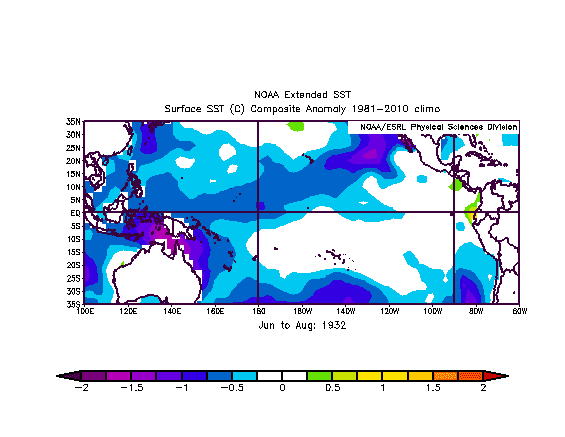
Here is my full analog package SST blend:

If we compare it to this year, notice the similarities with the cool western gulf and warm AMO tripole. There is also cool water in nino 1 and 2.
ENSO

ENSO will be a very key driver for this years hurricane season. The european and canadian guidance suggest a weak modiki el nino throughout the summer with dryness around florida/cuba. The euro monthlies has a trough over the great lakes with a near normal hurricane season in the atlantic basin. It is suggesting two spreads of tracks, one extending from the MDR towards the gulf states and a second one along the eastern seaboard late in the season. Given the overall pattern in place, I agree with the overall tracks advertised by the european but disagree on ENSO state. Currently, we have an area of warmer then normal subsurface SST anomalies between 140E and the dateline. These anomalies may make an attempt to upwell in the central ENSO regions but in a modified form. 

We continue to see OLR anomalies clustering around the maritime continent/eastern IO which supports a neutral ENSO/weak la nina pattern. The atmosphere is not headed towards an el nino very quickly given the lack of a strong subsurface warmth which.

Mid tropospheric easterlies west of the date line and subsequent SOI rises will prevent an incoming el nino. A la nada or very weak el nino is what I am expecting by late summer. This should not prohibit hurricane development given the lag effect involved with a changeable ENSO state. With this being said, we need to look at other factors that can influence the hurricane season.


QBO

Currently we are experiencing a downwelling easterly QBO state which should strengthen into a westerly state by the summer. A downwelling easterly QBO will help promote easterly winds in the stratosphere with lower heights over the caribbean and an increased hurricane threat in the atlantic basin this summer. Notice how the easterlies are already beginning to strengthen in the subtropics around 50mb which is consistent with my analogs (1964 and 1969).
Hurricane Track Forecast

Within a positive AMO period we should always be on the lookout for hurricane tracks up the eastern seaboard. I think this year will be no different with several threats from the carolinas to New England and towards the eastern caribbean. Several of my analog years are pointing towards east coast storm tracks such as Isabel, Juan, Fran and Dora. Many systems may end up tracking just to the east of the northeast coast. In august and september several central caribbean and gulf of mexico tracks are likely as storms shift southwestwards and the bermuda high weakens. Florida will be in the middle of this  track spread which means that it is also at risk of several land falls. I don't feel as if this is a hurricane season like 2005 or 2004 but an above normal season is in the works with a -NAO likely this may with a build up of warm SST's in the MDR. 


Wednesday, 27 March 2013

Summer 2013 Outlook

Key points

  • The core of the heat will be centered across the eastern rockies and central plains states in june before shifting northwards as we head into july and august
  •  Drought conditions will persist across the central part of the CONUS and intensify across the intermountain west and southern prairies
  • Normal precipitation is expected across the great lakes and northeast with an active severe weather season likely across the ohio valley, great lakes and ontario. 
  • Much warmer then normal temperatures will occur in the western great lakes with near to above normal temperatures in the northeast.
  • Drier then normal conditions will continue across the southeast in june before much needed rains become more common in the second half of summer
ENSO
The current IRI forecast predicts a warm biased la nada as we head into the summer. I think that this is likely given the current warmer then normal sub surface temperature anomalies in the pacific. A full blown el nino is unlikely with a -PDO allowing warm water to drift southwards. SOI values have been variable lately with changeable SST's. Important to note is the warmest SST's are focused across eastern ENSO regions which would help intensify the summer heat. This would also allow more Sub Tropical energy to send moisture into the southeast and gulf coast states.
CPC forecast:
Current SST's consist of a warm AMO tripole with east based warmth in the tropical pacific.


Analogs

For my summer analogs I focused on years with a +AMO, -PDO and neutral ENSO state coming after a weak la nina. For my analogs I used 1932,1936, 1937, 1952 and 2012. Here are the temperature departures from the blend of years.

Precipitation

The temperature trend on these years is very similar to my summer thoughts. Notice how the heat is centered across the eastern rockies, plains states and extending northeast towards the great lakes. Cooler weather is likely along the west coast in the -PDO regime but the intermountain west may end up hotter and drier then the analogs show. An active monsoon season is present across the SW causing near to slightly below normal temperatures. I am also expecting wet conditions across the southeast in mid to late summer which is showing up in the analog package and european monthlies.


I will break down each analog year individually.

1932
This year had a moderate la nina in the winter season before a transition to la nada by the early summer. The warmest water temperature anomalies were centered in nino 1+2 which helped cause a hot summer across the central and eastern u.s. Dry conditions expanded northeast towards the great lakes region.
June to August SST's
Palmer Drought Index

Temperature Departure
1936
1936 was a weak la nina with a warm AMO and cold PDO horseshoe. This was a very hot summer across the western great lakes and plains states. I don't think this year will end up as hot as 1936 due to the neutral ENSO state predicted as opposed to a la nina which would enhance ridging in the mid latitudes.
Temperature Departures

Palmer Drought Index
1952

1952 had a downwelling easterly QBO with a neutral ENSO state coming after an el nino winter. The heat was centered further Southeast then I am expecting.
2012

I added last summer to my analog set because the ENSO trend was very similar along with the PDO and AMO states. I do expect a wetter and cooler summer across the northeast and eastern great lakes compared to last year. Notice the cooler anomalies across the southeast.
1937

This year came after three la nina years in a row which is very similar to our current ENSO state. Widespread warmth occurred similar to much of the 1930's and 1950's.

Tropical Forcing

This summer I am expecting negative OLR anomalies to develop across the indian ocean and maritime continent. This should work together with cooler SST's near the dateline with warmth off the coast of south america. The CFSv2 is pointing towards a northwards momentum transport between the equator and the tropic of cancer which favours more southern branch moisture and ridging in the central u.s. Phases 2-5 of the MJO/GWO will be common this summer in my opinion.


My Temperature Forecast


Precipitation Forecast:


Monday, 25 March 2013

Long Range Outlook

So far this march we have seen a tongue of colder then normal anomalies develop underneath a powerful block in the arctic. Here are the temperature departures for the month so far.
 Reduced: 90% of original size [ 565 x 437 ] - Click to view full image
Attached Image

I tried to match up some years so that we can get a better idea of what april will look like. Here is what march looked like in my analog years which is pretty close to what we have seen so far. Notice the warmer then normal anomalies across the bering sea with the tongue of cold extending from NW to SE.
 Reduced: 90% of original size [ 565 x 437 ] - Click to view full image
Attached Image

I will break down each year in my analog set.
1965

1965 had a very cold march with strong blocking west of greenland. The core of the cold was focused towards the northern plains, prairies and western great lakes. We also saw a transition to neutral ENSO conditions in the spring. In april of 1965 we saw cold shots focused across quebec, ontario and the great lakes with warmth building up across the southern tier of the CONUS.
 Reduced 40%
Attached Image
1064 x 429 (84.7K)

2002

In 2002 we saw very similar temperature anomalies in march with a slow transition out of cold bias la nada conditions. In april cold shots were common across the north as the PV drops south at times.
 Reduced 41%
Attached Image
1069 x 430 (84.36K)


2011

In spring 2011 a moderate to strong la nina began to weaken into a la nada state. It had a warm AMO and -PDO as well which matched nicely.
 Reduced 42%
Attached Image
1088 x 428 (86.22K)


2009

2009 is one of the top analogs in my set with a cold start and a warm finish. The ENSO signal was also very similar with a +AMO and -PDO. The first half of april is on the left and second half on the right.

 Reduced 41%
Attached Image
1073 x 429 (99.86K)


1996
In 1996 we had a very cold march with a similar tongue of cold showing up. Notice the strong blocking over greenland. ENSO trend also coming out of a weak/moderate la nina.
 Reduced 40%
Attached Image
1066 x 428 (83.39K)


Based on analogs, modelling and indices it looks like the first half of april will start off cool across the prairies, great lakes and quebec as pieces of the PV drop south. A weak -NAO and ridge along the west coast will allow cold shots to move down with warmer temperatures across the southern u.s. Towards the end of the month the weak -NAO/AO couplet should begin to relax and the -PNA trough begin to re-establish itself along the west coast. This will allow the heat from the south to begin to move northwards towards the ohio valley, great lakes and northeast. I still think that moisture stays above normal in and around the GL's with northern branch features dropping down, especially in the first half of the month. I do see a drier trend in the great lakes towards the end of the month with the SE ridge strengthening and less blocking across greenland. With features moving into the ridge expect some severe weather to break out, mostly south of the canadian border but a shift northwards is likely in may. Once we get out of this cold pattern, it looks like a quick snap to above normal conditions is likely.