Monday, 14 January 2013

Early February Looks Stormy


AAM has moved into the negative territory with a very negative anomaly centred near 30N. This favours higher heights near alaska and a continuation of a negative EPO pattern. The 12z ECMENS EPO forecasts confirm this up until the 20th of the month. The -EPO signal is caused by the poleward movement of warm tropical air to higher latitudes.
 Reduced: 84% of original size [ 604 x 491 ] - Click to view full image
Attached Image

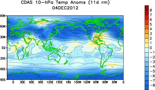
Mountain torque values have been on the rise but i believe the SSW has peaked and will begin to tone down at 10 and 30mb as we are seeing negative torque values showing up near 30N. Equatorward movement of frictional torque values favours a stormier pattern across the north pacific in the next two weeks with several systems moving along in the flow. A rossby wave train pattern has set up across the pacific.
 Reduced: 90% of original size [ 565 x 437 ] - Click to view full image
Attached Image
As a result a much stormier pattern will take place across the eastern and central part of the u.s between february 1st and 15th. Eastward propagation of the MJO in the southwest pacific will lose amplitude as it moves into phase 7 which looks very likely in the next 5 days. Major disagreements showing up between the ECMF, GEFS and the UKMET ENS MJO forecasts. I like a blend of the 3 but not quite as amped up as the GEFS and UKME. It does look like the MJO will lost amplitude in phases 7 or 8 which means that the GWO, SSW and pacific pattern will have more significant roles in the weather pattern for the end of jan and beginning of february. Eastward MJO progress should allow a kelvin wave to form around the date line as pressures rise across the maritime continent. Currently, easterlies are dominating across the equatorial pacific but a WWB in the western regions will cause a more nino like pacific pattern to set up. The current GWO phase is trending in that direction with a weak phase 5 setup. SST's can rebound in nino 3 and 4 with a brief SOI drop and a more active STJ for early february.
Attached Image

Sunday, 13 January 2013

Arctic Blast On The Way

After this weeks january thaw a return to much colder conditions is in store for central and eastern north america as the frigid air in the west makes its way eastwards. Temperatures wil begin to drop off on monday and tuesday as a cold front moves through the east.

After this the polar vortex will begin to sink southwards into the upper great lakes region and into northern ontario. Now I want to break down what is occurring in the atmosphere to initiate this change to a much colder pattern.

Part 1: Major Stratospheric Warming Event
Temperatures in the middle and upper stratosphere have soared lately with near record warmth at 10, 30 and 50mb. This warming has reversed the wind direction in the stratosphere which will help to suppress  the troposphere and cause very cold air to rush down to the surface between the 18th-25th of january. As a result of this the Arctic Oscillation will crash and the polar jet stream will weaken allowing arctic air from the polar vortex to move south. Areas that will have to endure the brunt of the cold include the upper midwest, eastern canada, northern new england and the great lakes region.
Part 2: Tropical Forcing
As the stratospheric warming supports this major cold shot in the east the tropics will become more favourable as well. Right now the MJO is in phase 6 with convection centered across the maritime continent. A very strong MJO wave has formed as a result of some very strong solar activity. This wave is forecast to propagate eastwards into phase 7 and weaken meaning two things 1) The MJO will have less of an effect on our weather pattern 2) The MJO is moving into much more favourable phases for cold which will help to suppress the SE ridge. Less of a fight will occur between the warmth and cold air with the cold taking hold in the end.
The eastward propagation of the MJO will also help to create a kelvin wave in the west/central pacific which should help to drop the daily SOI numbers and warm the western ENSO regions. The kelvin wave should form once the MJO propagates east near the date line as pressures rise to the NW and a more westward wind alignment occur . West based warmth in the pacific supports cold across eastern north america which is why I believe that february will be a cold month from the rockies eastwards. 


Part 3: Atmospheric Teleconnections
As frigid air makes its way into the mid latitudes favourable changes in the pacific pattern will help to lock the cold air into the east for several days with temperatures dipping to the coldest levels so far this year. We are seeing changes in the PNA index, meaning that a ridge will amplify along the west coast by the 18th allowing the first shot of cold to move southwards. This along with enhanced blocking over the pole will allow a strong trough to form over the east and central part of the continent. The pattern change is supported by the european and GFS ensembles.

European Ensembles for the 18th show the - East Based NAO, -AO, -EPO and +PNA pattern:
850mb temperature anomalies respond accordingly:
A second shot of cold air will follow after the 20th and this will be aimed further south and east with frigid temperatures being felt in the ohio valley, east coast, midwest and great lakes. This shot of cold air will be more severe then the first one as the polar vortex takes a big hit from the SSW event which results in a complete collapse. Daytime highs will not get above 15F during this cold shot in new york city and chicago if this forecast verifies.
As you can see it is not just the modelling but it is also the physical drivers on the table that support the polar vortex collapse and turn to a much colder pattern in the east and central part of the continent. Feel free to post any questions and comments you may have!

Tuesday, 8 January 2013

Cold Coming, La Nina possible this spring?


Record warming in the stratosphere should deliver a healthy cold shot around the 20th of january:
 Reduced 11%
Attached Image
720 x 432 (25.99K)

MJO signal favours a southeast ridge and further NW inland storm track with a trough along the california coast.
 Reduced: 93% of original size [ 547 x 547 ] - Click to view full image
Attached Image
After the initial shot of arctic air we may see the pattern move to a very stormy one for ontario and quebec with a more la nina like look for the last few days of january and first half of february. The LRC supports several storms in this time period. The Pacific SST's resemble a weak east based la nina look which favours cold in the great lakes and northern plains. It looks like their will be some warming in western regions as subsurface warmth upwells.
 Reduced 50%
Attached Image
1280 x 1024 (500.96K)

GLAAM is moving into a weak phase 4/5 which favours a la nina type of pattern. Frictional torque values are negative between 30 and 60 north. With the MJO stalling in phases 6 and 7 the SOI will pop positive with pressure falls near darwin and a HP anomaly further east. Trade winds are present in the equatorial pacific will LP anomalies propagating eastwards across the northern pacific which will strengthen the la nina that may come on this spring. Right now a la nada biased cool looks present.
 Reduced: 90% of original size [ 565 x 437 ] - Click to view full image
Attached Image
8-10 day means look la nina like:

 Reduced 38%
Attached Image
1024 x 819 (96.07K)

Sunday, 6 January 2013

Winter Comeback On The Way

Their is some very interesting weather to talk about this morning! First let's take a look at the latest ECMWF forecast for the MJO. Notice the eastward propagation through phases 4,5 and 6 which line up nicely with our January thaw that I believe is coming to an end by the 18-23 of january. This lines up well with the MJO wave which is entering phase 7 which  favors eastern cold by the 18th. The UKMET ensembles have a similar outcome and are basically in line with the european albeit more amplified.
Paul Roundy's OLR site goes out a little bit further into the long range. From now until the 18th we can see the MJO transitioning from phase 6 to 7 but it gets really interesting from the 19th to 26th when the MJO propagates into phases 8 and 1. During this time period the stratospheric warming event begins to push arctic air into the mid latitudes. This is one reason why I believe the cold will eventually progress eastwards after the 20th of january.
Phases 8 and 1 of the MJO look like this in January:
Phase 8
Phase 1


 Quite a battle will be going on from the 16th to 25th as the arctic air is pressing against the southeast ridge. A baroclinic zone will set up across the appalachians, interior northeast, eastern great lakes and the coastal plain. With a SE ridge and east based blocking in place most storms will take more of an inland track but some east coast storms are very possible.

500mb height field shows the blocking connecting over the pole and a stormy pattern for the interior


 Now let me explain some of the other players on the field. A very important observation is the current  SOI drop caused by the eastward propagation of a kelvin wave in the pacific. This is yet another sign that will help to transport very cold air into north america which is in line with the MJO and SSW events. Daily contribution to the SOI is well negative. This drop in the SOI will force a compensation across north america which will help flip the pattern to colder.


Another interesting player on the field is the extreme amount of blocking that is forecast to take place. It looks like the ECMWF and GFS are showing what should happen given the physical drivers on the field which i have displayed for you guys. The 06z GFS OP is pumping two strong ridges, one across alaska and another across eastern greenland. These ridges connect over the top which really allows the cold air to penetrate the east. An event like this is called a cross polar flow pattern which means that the jet stream extends so far north that it can pull siberian air(extremely cold air) well south into the north american weather pattern. The GFS shows this type of setup with a deep trough over the central and eastern u.s. Keep in mind this is a run of the operational past 240 hours out so caution is warranted. The ensembles have a less amplified solution which is common this far out.  The CPF event continues for several days as the PV collapses southwards after the 20th.


The european OP is moving towards the GEFS:
The NAO responds:
As you can see current observations from the tropics, stratosphere, indices and now the modelling are all pointing towards a huge change in the overall North American weather pattern. Don't put away the shovels just yet the second half of winter is going to be a wild ride!


Saturday, 5 January 2013

Sudden Stratospheric Warming Event Intensifying

A major stratospheric warming event is taking place across northeast asia and expanding northeastwards towards the north pole. The most notable warming is taking place between 1mb and 30mb in the upper stratosphere.
Notice the sudden stratospheric warming at 10mb:

This warming is beginning to work its way down to the 50 and 70mb levels. The effects of the SSW event are causing an expansion in the stratosphere which suppresses and cools the troposphere. This event also weakens the polar jet stream which allows the cold air bottled up across the arctic to move southwards into mid latitudes. Currently a positive arctic oscillation(strong polar jet stream) is in place but that should change soon as the stratosphere continues to warm and weaken the vortex. Their are three reasons why I believe that the stratospheric warming event will continue to intensify throughout the next week which will cause the sensible weather across north america to become very cold for the end of january and into february.

Part 1: East Asian Mountain Torque Spike

East Asian Mountain Torque Values are increasing and have spiked positive which will help to strengthen planetary wave breaking events across east asia. In simpler english, the current warming that is taking place across east asia will continue to feed warmth towards the north pole. Weakening of the polar vortex has already taken place from our current warming and the negative phase of the QBO. Further warming in the next seven days will be too much for the PV to withstand. You can see the rapid warming in the upper stratosphere on the loop below.
Current warming will cause a complete split in the polar vortex which is shown on the european stratosphere forecast for day 3. Notice one piece of the vortex is centred across north america with a weaker piece in central europe. This weakening of the vortex will cause a huge amount of arctic air to get transported underneath into central and eastern north america. A 2-3 week lag time occurs between the SSW event and cold air transport to the surface which means that we can expect the cold to reach eastern north america by the 20th-25th of january. Very cold air will last until the beginning of february with this setup.
Part 2: West Pacific Kelvin Wave 

Latest observations point towards another kelvin wave formation across the western pacific. Kelvin waves are pockets of warmth that move eastwards along the thermocline(subsurface boundary between cold and warm water) in the equatorial pacific. Kelvin waves contain westerly wind bursts aloft which cause two major implications on our weather pattern. 1) Transport warm water from the western pacific into nino regions 3 and 4(central pacific), further enhancing the el nino and subtropical jet disturbances. 2)  It Causes major drops in the SOI by transporting major warmth into the upper atmosphere. The atmosphere always need to balance itself out so it therefore cools north america as a result of the SOI drop. Relating this back to out stratospheric warming event the kelvin wave helps to transport additional warmth into the upper atmosphere which disrupts the polar vortex even further. Take note of the kelvin wave located near 140 east longitude and 100 meters below the surface.
 All of these atmospheric factors point towards a major stratospheric warming event continuing to intensify which will weaken the polar vortex and transport arctic air into north america from mid january to the beginning of february. The cold will invade the west and northern plains first with the frigid air moving in between the 12th and 20th. The cold should progress east by the 20th as is natural when a large amount of arctic air is pushing eastwards and spreading out into an upstream ridge.  The core of the cold will be focused at the ohio valley, midwest, great lakes and northern new england as opposed to the mid-atlantic states.
GFS temperature anomaly forecast from the 15th to 20th of january:


 This cold weather pattern will continue into the beginning of february and perhaps beyond if more stratospheric warming events continue to occur. The GFS and ECMWF forecast models believe that another warming will happen in about 7-10 days.


Friday, 4 January 2013

Winter Is Coming Mid Month

In the Equatorial Pacific we can see the upwelling of colder then normal SST anomalies from 140w to 90w.
Attached Image
This has contributed to the cooling of nino regions 3, 2 and 1. Further west the recent kelvin wave and WWB has caused subsurface warming in the western nino regions. Intensification of the WWB near 120w has worked to upwell warmth along the thermocline.
Attached Image
We will see another spike in SST anomalies in nino 3 and 4 as the warming reaches the surface further east and MJO propagates into the western pacific around the 15th. This should help to enhance -OLR anomalies causing further warming in nino 4. The west/central based warmth along with the SOI drops should allow for significant cooling across eastern and central north america in late january and february. A tropical cyclone NE of New Zealand is contributing to pressure drops near tahiti but as it moves out a strong HP anomaly should move into the area. MJO propagation across the Eastern IO/maritime continent will allow for further SOI rises in the short range as low pressure anomalies continue across southeast asia. This signals a relaxation in the subsurface warming/SOI drops for the short term but as the EAMT gets going we should see these LP anomalies attempt to move eastwards in line with the MJO wave around mid month.
 Reduced 38%
Attached Image
1024 x 768 (209.96K)


The ECMENS are coming more in line with the GEFS pointing to an east based -NAO, -EPO and neutral to -PNA developing past the 15th which forces the core of the cold into the rockies/northern plains with storminess across the st lawrence valley, interior northeast and ohio valley. A strong SE ridge keeps the east coast above normal in this time period. Past 300 hours the GEFS is pointing towards a shift west in the blocking which allows the cold to propagate east and sets up the east coast for more storminess. Take the GEFS FWIW at this range but this is possible as the effects of the SSW slowly beat down the SE ridge from the 20th onwards. The brunt of the cold and snowfall should stay north of 1-95 with this setup overall. We are seeing conflicting signals between the unfavourable MJO, SOI drops, SSW and central based ENSO warming but i expect the cold to win out in much of the east by the 20th as the MJO losses amplitude and other cold signals win out. 

Thursday, 3 January 2013

Major Stratospheric Warming Event


MJO in phases 4,5 and 6 will cause a very warm pattern until the 15th of january with a ridge in the eastern part of north america and a +NAO/AO combination. The wave will be fairly strong but will propagate eastward quickly, limiting the warm pattern to a fairly short period of time.
 Reduced: 93% of original size [ 547 x 547 ] - Click to view full image
Attached Image

After the 15th the wave will weaken and move towards the COD and could move into phases 7 and 8 later in late january or february but that is still uncertain right now. Phase 7 looks like this in january, notice the east based -nao, +PNA and -EPO pattern with a trough in the bering sea.
 Reduced 25%
Attached Image
847 x 655 (35.27K)


A less amplified MJO wave means after the 15th we need to look for other factors that will influence our weather pattern across north america. An active pattern will likely return mid and late month as an active SE ridge is present with a trough digging into the west/eastern rockies. A large thermal gradient will set up a BZ across the eastern GL, ohio valley and interior northeast. Look for several snowfall opportunities past the 15th as more cold air gets established into the pattern with pieces of arctic air moving down from western canada. Also a very active west pacific LP wave train has set up with poleward movement of frictional torque. This lines up with a weak phase two of the GWO(more of a la nina pattern) and means that we can expect a stormier pattern mid to late month.

Further down the road the effects of the current SSW will take hold on the east as the trough in the west eventually progresses eastwards. An initial warming has already weakened the vortex with warming near the pole but another warming event will take hold across northern canada with rossby waves and a +EAMT reinforcing the warming. This should be enough to cause a complete collapse of the PV. A wave 2 pattern will set up, splitting the vortex with one piece moving onto our side of the globe and another towards eurasia. With a two week lag, expect very cold temperatures to move into the east past the 20th of january. With a strong trough in the west large pressure rises should occur across NW canada which will press against the ridge before the cold wins out by the 20-25th. The GFS is probably too fast with bringing the cold air eastwards which is in line with its MJO forecasts. The ECMENS and euro weeklies are beginning to catch on to the colder pattern and a -NAO/AO pattern caused by the SSW event.
 Reduced 38%
Attached Image
1024 x 768 (388.26K)

Wednesday, 2 January 2013

Looking Ahead Into February and March


For my February analog set i looked for years with a similar temperature trend to this year as well as a similar 500mb setup. I put less focus into the ENSO trend with these years because of the weak signal this year but most of my years are central/west based el nino's. First lets start off by taking a look at what this december looked like to try and match it up with previous years. Take note of the above normal temperature departures that take over much of the lower 48 states as well as eastern canada. Very cold air is locked up across NW canada including northern B.C. A tongue of cold extends into the prairie provinces with much warmer temperatures dominating further SE.
Attached Image


500mb height field shows a strong trough in the west with a ridge upstream across eastern canada and blocking towards greenland. Notice the strong ridge across the bering sea which causing energy to dump into the west promoting an eastern ridge most of the time. Another key feature is the trough centered west of hawaii which promotes a ridge in the bering sea and a trough in the west. For eastern cold we like to see the trough east of hawaii to pump a western ridge and an eastern trough.
Attached Image


Now lets look at some past years with a similar match to december 2012 so that we can try and get a better handle on what might occur down the road. Taking a look at surface temperatures we can see the warmth dominating over much of the u.s extending up towards eastern canada and greenland. All of the cold air is locked up further NW which is very similar to this years december pattern.
Attached Image


On the 500mb height field we notice a ridge in the bering sea as well as a trough west of hawaii which is very similar to this year and is a key player for the north american weather pattern. A trough is centered along the west coast and gulf of alaska with ridging further east across the central and eastern u.s. Blocking is found across hudson bay and greenland although weaker then this year.
Attached Image


Lets take a look at what february and march looked like in these years. 
I like what the february analogs look like and believe that a broad based trough across the nation makes sense. The -PNA regime will probably continue but cold will be able to penetrate the east with more blocking over the top. With the SSW event taking place, it should drive the cold air south for the end of january and much of february. An active storm track will set up for the first half of the month in the eastern great lakes, quebec and the northeast.
500mb setup shows the trough retrograding off the east coast and another broad trough across the continents midsection:
Attached Image

Surface Temperatures are pretty inline with my thinking but i think the coldest anomalies will be focused further NW across the prairies, northern plains as well as NW canada with the tongue of cold extending into the northeast. A SE ridge may get going later in the month:
Attached Image

Heading into march we can see the warmth is confined to the southern u.s with the cold air locked up much further north with a positive NAO. March is still pretty far out and is a low confidence forecast at the moment but I do believe that the southern u.s will average warmer then normal with temps being held back across the great lakes, northern plains and west coast. How much colder then normal is still uncertain right now but i feel the most confident along the west coast within the negative PDO regime. A late start to spring is likely along the west coast with an early start to spring in the SE, midwest and mississippi valleys.
2m Temps:
Attached Image
500mb heights:
Attached Image