After this the polar vortex will begin to sink southwards into the upper great lakes region and into northern ontario. Now I want to break down what is occurring in the atmosphere to initiate this change to a much colder pattern.
Part 1: Major Stratospheric Warming Event
Temperatures in the middle and upper stratosphere have soared lately with near record warmth at 10, 30 and 50mb. This warming has reversed the wind direction in the stratosphere which will help to suppress the troposphere and cause very cold air to rush down to the surface between the 18th-25th of january. As a result of this the Arctic Oscillation will crash and the polar jet stream will weaken allowing arctic air from the polar vortex to move south. Areas that will have to endure the brunt of the cold include the upper midwest, eastern canada, northern new england and the great lakes region.
Part 2: Tropical Forcing
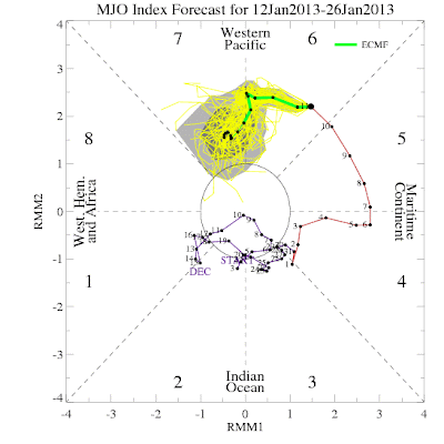
As the stratospheric warming supports this major cold shot in the east the tropics will become more favourable as well. Right now the MJO is in phase 6 with convection centered across the maritime continent. A very strong MJO wave has formed as a result of some very strong solar activity. This wave is forecast to propagate eastwards into phase 7 and weaken meaning two things 1) The MJO will have less of an effect on our weather pattern 2) The MJO is moving into much more favourable phases for cold which will help to suppress the SE ridge. Less of a fight will occur between the warmth and cold air with the cold taking hold in the end.
The eastward propagation of the MJO will also help to create a kelvin wave in the west/central pacific which should help to drop the daily SOI numbers and warm the western ENSO regions. The kelvin wave should form once the MJO propagates east near the date line as pressures rise to the NW and a more westward wind alignment occur . West based warmth in the pacific supports cold across eastern north america which is why I believe that february will be a cold month from the rockies eastwards.
Part 3: Atmospheric Teleconnections
As frigid air makes its way into the mid latitudes favourable changes in the pacific pattern will help to lock the cold air into the east for several days with temperatures dipping to the coldest levels so far this year. We are seeing changes in the PNA index, meaning that a ridge will amplify along the west coast by the 18th allowing the first shot of cold to move southwards. This along with enhanced blocking over the pole will allow a strong trough to form over the east and central part of the continent. The pattern change is supported by the european and GFS ensembles.European Ensembles for the 18th show the - East Based NAO, -AO, -EPO and +PNA pattern:
850mb temperature anomalies respond accordingly:
A second shot of cold air will follow after the 20th and this will be aimed further south and east with frigid temperatures being felt in the ohio valley, east coast, midwest and great lakes. This shot of cold air will be more severe then the first one as the polar vortex takes a big hit from the SSW event which results in a complete collapse. Daytime highs will not get above 15F during this cold shot in new york city and chicago if this forecast verifies.
As you can see it is not just the modelling but it is also the physical drivers on the table that support the polar vortex collapse and turn to a much colder pattern in the east and central part of the continent. Feel free to post any questions and comments you may have!


No comments:
Post a Comment