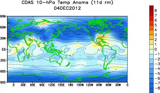
Notice the sudden stratospheric warming at 10mb:

This warming is beginning to work its way down to the 50 and 70mb levels. The effects of the SSW event are causing an expansion in the stratosphere which suppresses and cools the troposphere. This event also weakens the polar jet stream which allows the cold air bottled up across the arctic to move southwards into mid latitudes. Currently a positive arctic oscillation(strong polar jet stream) is in place but that should change soon as the stratosphere continues to warm and weaken the vortex. Their are three reasons why I believe that the stratospheric warming event will continue to intensify throughout the next week which will cause the sensible weather across north america to become very cold for the end of january and into february.
Part 1: East Asian Mountain Torque Spike
East Asian Mountain Torque Values are increasing and have spiked positive which will help to strengthen planetary wave breaking events across east asia. In simpler english, the current warming that is taking place across east asia will continue to feed warmth towards the north pole. Weakening of the polar vortex has already taken place from our current warming and the negative phase of the QBO. Further warming in the next seven days will be too much for the PV to withstand. You can see the rapid warming in the upper stratosphere on the loop below.
Current warming will cause a complete split in the polar vortex which is shown on the european stratosphere forecast for day 3. Notice one piece of the vortex is centred across north america with a weaker piece in central europe. This weakening of the vortex will cause a huge amount of arctic air to get transported underneath into central and eastern north america. A 2-3 week lag time occurs between the SSW event and cold air transport to the surface which means that we can expect the cold to reach eastern north america by the 20th-25th of january. Very cold air will last until the beginning of february with this setup.

Part 2: West Pacific Kelvin Wave
Latest observations point towards another kelvin wave formation across the western pacific. Kelvin waves are pockets of warmth that move eastwards along the thermocline(subsurface boundary between cold and warm water) in the equatorial pacific. Kelvin waves contain westerly wind bursts aloft which cause two major implications on our weather pattern. 1) Transport warm water from the western pacific into nino regions 3 and 4(central pacific), further enhancing the el nino and subtropical jet disturbances. 2) It Causes major drops in the SOI by transporting major warmth into the upper atmosphere. The atmosphere always need to balance itself out so it therefore cools north america as a result of the SOI drop. Relating this back to out stratospheric warming event the kelvin wave helps to transport additional warmth into the upper atmosphere which disrupts the polar vortex even further. Take note of the kelvin wave located near 140 east longitude and 100 meters below the surface.

All of these atmospheric factors point towards a major stratospheric warming event continuing to intensify which will weaken the polar vortex and transport arctic air into north america from mid january to the beginning of february. The cold will invade the west and northern plains first with the frigid air moving in between the 12th and 20th. The cold should progress east by the 20th as is natural when a large amount of arctic air is pushing eastwards and spreading out into an upstream ridge. The core of the cold will be focused at the ohio valley, midwest, great lakes and northern new england as opposed to the mid-atlantic states.
GFS temperature anomaly forecast from the 15th to 20th of january:

This cold weather pattern will continue into the beginning of february and perhaps beyond if more stratospheric warming events continue to occur. The GFS and ECMWF forecast models believe that another warming will happen in about 7-10 days.

Excellent Job Sir
ReplyDeleteBravo!
ReplyDeleteThanks for your write-up on this website. From my own experience, there are times when softening right up a photograph might provide the digital photographer with an amount of an artistic flare. Often times however, this soft clouds isn’t precisely what you had in your mind and can sometimes spoil a normally good photograph, especially if you intend on enlarging that.
ReplyDeletelos angeles venue
Could not have asked for a better venue to have held our event. Everything was impeccable - from the decor to the food to the service.
ReplyDeleteSMM PANEL
ReplyDeleteSMM PANEL
iş ilanları
instagram takipçi satın al
hirdavatciburada.com
BEYAZESYATEKNİKSERVİSİ.COM.TR
servis
tiktok jeton hilesi
Good content. You write beautiful things.
ReplyDeletesportsbet
hacklink
mrbahis
hacklink
sportsbet
korsan taksi
mrbahis
taksi
vbet
dijital kartvizit
ReplyDeletereferans kimliği nedir
binance referans kodu
referans kimliği nedir
bitcoin nasıl alınır
resimli magnet
RJ1CMJ
beşiktaş
ReplyDeleteizmit
mersin
uşak
fatih
FYCD1D
yurtdışı kargo
ReplyDeleteresimli magnet
instagram takipçi satın al
yurtdışı kargo
sms onay
dijital kartvizit
dijital kartvizit
https://nobetci-eczane.org/
H261S
resimli magnet
ReplyDeleteresimli magnet
çerkezköy çatı ustası
silivri çatı ustası
dijital kartvizit
0H686X
silivri çatı ustası
ReplyDeletefal baktır
indirmeden oynanan oyunlar
ünye veteriner
https://yoltransfer.com.tr/
BYY
https://bayanlarsitesi.com/
ReplyDeleteGüneşli
Halkalı
Florya
Akbatı
31HMM
ankara parça eşya taşıma
ReplyDeletetakipçi satın al
antalya rent a car
antalya rent a car
ankara parça eşya taşıma
YFX5
498DA
ReplyDeleteSivas Şehir İçi Nakliyat
Muğla Evden Eve Nakliyat
Konya Lojistik
Çorum Evden Eve Nakliyat
Kars Lojistik
Tokat Şehirler Arası Nakliyat
Amasya Lojistik
Ordu Şehirler Arası Nakliyat
Siirt Şehirler Arası Nakliyat
cfimi.com
ReplyDeletekırklareli
zonguldak
kilis
çankırı
WİZOBA
6F2D1
ReplyDelete%20 binance indirim kodu
F513C
ReplyDeletekayseri bedava sohbet uygulamaları
izmir mobil sesli sohbet
ankara parasız sohbet siteleri
tekirdağ yabancı canlı sohbet
bartın nanytoo sohbet
trabzon tamamen ücretsiz sohbet siteleri
maraş telefonda görüntülü sohbet
kırklareli canlı sohbet odası
erzurum canli goruntulu sohbet siteleri
91A9B
ReplyDeleteSivas Rastgele Görüntülü Sohbet
antep sesli sohbet siteleri
telefonda canlı sohbet
bolu kadınlarla görüntülü sohbet
malatya sohbet siteleri
Ordu Chat Sohbet
konya görüntülü sohbet siteleri ücretsiz
adana görüntülü sohbet uygulama
ığdır canlı sohbet odası
1876C
ReplyDeleteKaspa Coin Hangi Borsada
Milyon Coin Hangi Borsada
Soundcloud Dinlenme Satın Al
Dxy Coin Hangi Borsada
Referans Kimliği Nedir
Coin Oynama
Dxgm Coin Hangi Borsada
Aptos Coin Hangi Borsada
Kripto Para Nasıl Oynanır
FC755C66DE
ReplyDeletetakipçi
Sıra Bulucu
Free Fire Elmas Kodu
M3u Listesi
3D Car Parking Para Kodu
Pokemon GO Promosyon Kodu
Bitcoin En Güvenilir Nereden Alınır
Tinder Promosyon Kodu
Türkiye Posta Kodu
B9197BC649
ReplyDeletegerçek türk instagram takipçi
tiktok beğeni satın al
türk takipçi
fake takipçi
düşmeyen takipçi
AC32C2AC00
ReplyDeletegarantili türk takipçi
tiktok beğeni satın al
türk takipçi
instagram takipçi
aktif takipçi