
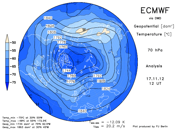
This -EPO pattern will cause the AO and NAO to dip into negative territory which is in line with the index forecasts. I think the pattern change will begin with the passage of the cold front this friday. I am expecting slightly below normal Temps for week one of december. Temp anomalies will begin to decrease more and more leading to a well below normal week two and three of the month. This winter temps will vary in the east when the -epo pattern relaxes and a trough digs into the west once in a while. We would left with a zonal flow in the east. The storm track will depend on the the positioning of the greenland ridge which will shift from west to east as will the trough in the east. East based blocking favours storminess further west in the GL/OV where the BZ sets up. In a west based -NAO the storminess shifts southeast of On and Quebec. I think the cold will continue to dominate across southeastern north america, including southern ontario in january and february. Stratospheric temps over our side of the globe and in north-central asia are above normal which is what happened over europe and asia last year and we no what that lead too. Although overall the stratosphere is colder then normal the below normal anomalies are focused over the north pole, eastern europe and greenland.
Keep your eyes on the MJO, phases 6 through 1 are good for cold and snow in the east while phases 2 through 5 put the trough in the west with zonal to ridging in the east. Right now it is not in a favourable phase which lines up with the current pattern. It should shift soon into the COD and may pop back out on the opposite side which would be in line with current modelling for a pattern change at the end of the month. This is the wild card i would say for the long range pattern and would go against the consensus if it were to meander around in phases 3-5. I would highly doubt this at this point in time.


No comments:
Post a Comment